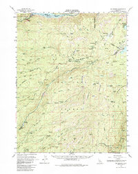
1956 Map of Big Meadow
USGS Topo · Published 1985About this map
Stanislaus National Forest and Eldorado National Forest dominate this mid-century landscape, where high-altitude meadows and summer camps serve as the primary human footprint. The map highlights a remote network of backcountry outposts including Mattley Cabin, Cuneo Camp, and Del Orto Camp, alongside small settlements like Airola and Ganns. The geography is defined by deep river canyons such as the North Fork Mokelumne River and the Middle Fork Stanislaus River, with significant water management infrastructure evidenced by the Salt Springs Reservoir and Utica Reservoir.
Find a feature on this map
99 named features on this map. Tap any name to fly to it.
Don’t see what you’re looking for? This feature index may not catch every label — zoom into the map to look around manually.
Map Details
Editions of this 1956 Big Meadow Map
4 editions found
Other maps of this area

1889 · Pyramid Peak
USGS Topo · 1:125,000

1889 · Markleeville
USGS Topo · 1:125,000

1891 · Markleeville
USGS Topo · 1:125,000

1891 · Big Trees
USGS Topo · 1:125,000

1891 · Pyramid Peak
USGS Topo · 1:125,000

1893 · Markleeville
USGS Topo · 1:125,000

1894 · Big Trees
USGS Topo · 1:125,000

1895 · Pyramid Peak
USGS Topo · 1:125,000

1896 · Dardanelles
USGS Topo · 1:125,000

1896 · Pyramid Peak
USGS Topo · 1:125,000