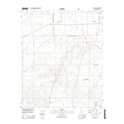
2014 Map of Big Pug Tank
USGS Topo · Published 2014About this map
Sitgreaves National Forest dominates this section of the Mogollon Plateau, where a complex network of ephemeral drainages and constructed watering points defines the landscape. The reliance on water management for ranching and forest operations is evident in the numerous named catchments, including Big Pug Tank, Clay Springs Tank, and Holy Oak Tank. These features are connected by a web of service roads and local tracks like Bum Heel Ranch Rd and Indian Pottery Rd. Significant natural drainages such as Cottonwood Wash and Day Wash cut through the terrain, while Walker Lake provides a larger focal point for the surrounding ecosystem. This 2014 survey documents the continued infrastructure of the high plateau, mapping the relationship between modern access roads like State Hwy 277 and the vital springs and draws such as Perkins Spring Draw that have historically sustained the area.
Find a feature on this map
53 named features on this map. Tap any name to fly to it.
Don’t see what you’re looking for? This feature index may not catch every label — zoom into the map to look around manually.
Map Details
Editions of this 2014 Big Pug Tank Map
This is the sole edition of this map. No revisions or reprints were ever made.
Other maps of this area

1886 · Holbrook
USGS Topo · 1:250,000

1893 · Holbrook
USGS Topo · 1:250,000

1954 · Holbrook
USGS Topo · 1:250,000

1957 · Holbrook
USGS Topo · 1:250,000

1958 · Holbrook
USGS Topo · 1:250,000

1960 · Holbrook
USGS Topo · 1:250,000

1961 · Clay Springs
USGS Topo · 1:62,500
1970 · Cactus Flat
USGS Topo · 1:24,000
1970 · Second Knolls
USGS Topo · 1:24,000
1970 · Pinedale
USGS Topo · 1:24,000