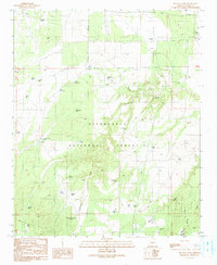
1990 Map of Big Pug Tank
USGS Topo · Published 1991About this map
Sitgreaves National Forest dominates this high-altitude landscape in Navajo County, characterized by a complex network of seasonal washes and livestock watering tanks. The drainage patterns of Day Wash and Cottonwood Wash carve through the terrain, supporting localized water sources like Big Pug Tank and Little Pug Tank. Evidence of ranching and early infrastructure appears in the form of a Corral near Long Hollow Tank and a Pipeline traversing the northern section. Notable natural features such as Walker Lake and Day Spring provide a contrast to the man-made improvements scattered across the forest, including Holy Oak Tank and the namesake Big Pug Tank. The southern portion of the map transition into draws, including Town Draw and Perkins Draw, near the settlement area of Clay Springs.
Find a feature on this map
41 named features on this map. Tap any name to fly to it.
Don’t see what you’re looking for? This feature index may not catch every label — zoom into the map to look around manually.
Map Details
Editions of this 1990 Big Pug Tank Map
This is the sole edition of this map. No revisions or reprints were ever made.
Other maps of this area

1886 · Holbrook
USGS Topo · 1:250,000

1893 · Holbrook
USGS Topo · 1:250,000

1954 · Holbrook
USGS Topo · 1:250,000

1957 · Holbrook
USGS Topo · 1:250,000

1958 · Holbrook
USGS Topo · 1:250,000

1960 · Holbrook
USGS Topo · 1:250,000

1961 · Clay Springs
USGS Topo · 1:62,500
1970 · Cactus Flat
USGS Topo · 1:24,000
1970 · Second Knolls
USGS Topo · 1:24,000
1970 · Pinedale
USGS Topo · 1:24,000