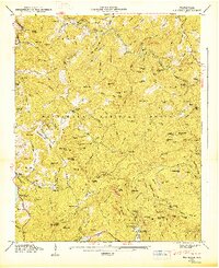
1947 Map of Big Ridge
USGS Topo · Published 1947About this map
The Tuckasegee River carves through this portion of Jackson County shortly after the second World War, defining a landscape of high summits and deep gaps. Settlement patterns are focused around community hubs like Big Ridge Ch and Neddie Mtn Ch, along with the Rock Bridge Sch. These points of assembly suggest the enduring social structure of the mountain coves before mid-century modernization fully took hold. The map details the waters of Glenville Lake and Fairfield Lake, which sit at the edge of the Nantahala National Forest. Prominent landmarks such as Indian Place and the Island Ford provide evidence of historical river crossings and ancient land use. High-elevation ridges like Lizzie Mountain and Glassyrock Ridge separate the various watersheds, including the Horsepasture River which flows southward toward the state line.
Find a feature on this map
149 named features on this map. Tap any name to fly to it.
Don’t see what you’re looking for? This feature index may not catch every label — zoom into the map to look around manually.
Map Details
Editions of this 1947 Big Ridge Map
This is the sole edition of this map. No revisions or reprints were ever made.
Other maps of this area

1891 · Cowee
USGS Topo · 1:125,000

1897 · Cowee
USGS Topo · 1:125,000

1905 · Pisgah
USGS Topo · 1:125,000

1906 · Pisgah
USGS Topo · 1:125,000

1907 · Cowee
USGS Topo · 1:125,000

1935 · Sam Knob
USGS Topo · 1:24,000

1935 · Cashiers
USGS Topo · 1:24,000

1935 · Tuckaseigee
USGS Topo · 1:24,000

1935 · Lake Toxaway
USGS Topo · 1:24,000

1935 · Reid
USGS Topo · 1:24,000