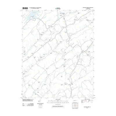
2010 Map of Big Ridge Park
USGS Topo · Published 2010About this map
Big Ridge Lake and the Big Ridge Recreation Dam anchor the northern landscape of this region, where the terrain is defined by a dense network of ridges and narrow valleys. This area in East Tennessee is home to a significant concentration of family burial grounds and small community cemeteries, reflecting generations of local settlement. Genealogists will find numerous sites of interest, from the New Loyston Cemetery to the Byrams Fork Cemetery and Vandagriff Cemetery. The map illustrates a rural economy historically tied to the land and its waterways, such as Hinds Creek and Bullrun Creek. Distinctive place names like Blue Mud Valley, Texas Valley, and Possum Valley highlight the local vernacular and the way the population dispersed throughout the ridge-and-valley landscape. Landmarks such as the Andersonville Dock suggest the importance of the lake for both local recreation and geography.
Find a feature on this map
124 named features on this map. Tap any name to fly to it.
Don’t see what you’re looking for? This feature index may not catch every label — zoom into the map to look around manually.
Map Details
Editions of this 2010 Big Ridge Park Map
This is the sole edition of this map. No revisions or reprints were ever made.
Other maps of this area

1893 · Briceville
USGS Topo · 1:125,000

1895 · Briceville
USGS Topo · 1:125,000

1896 · Briceville
USGS Topo · 1:125,000

1897 · Maynardville
USGS Topo · 1:125,000

1900 · Maynardville
USGS Topo · 1:125,000

1935 · Graveston
USGS Topo · 1:24,000

1935 · Fountain City
USGS Topo · 1:24,000

1936 · Gorryton
USGS Topo · 1:48,000

1936 · White Hollow
USGS Topo · 1:24,000
1936 · John Sevier
USGS Topo · 1:24,000