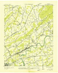
1936 Map of John Sevier
USGS Topo · Published 1936About this map
The Southern Railway corridor anchors this Knox County landscape, running parallel to the Holston River and serving the industrial and logistical hub at John Sevier. This survey, compiled from aerial photography just before the Second World War, shows a dense network of rural communities defined by ridge-and-valley topography. The massive classification yards at John Sevier Sta and the presence of the John Sevier Ch highlight the town's role as a major rail center.
Find a feature on this map
103 named features on this map. Tap any name to fly to it.
Don’t see what you’re looking for? This feature index may not catch every label — zoom into the map to look around manually.
Map Details
Editions of this 1936 John Sevier Map
This is the sole edition of this map. No revisions or reprints were ever made.
Other maps of this area

1886 · Knoxville
USGS Topo · 1:125,000

1892 · Knoxville
USGS Topo · 1:125,000

1894 · Knoxville
USGS Topo · 1:125,000

1895 · Knoxville
USGS Topo · 1:125,000

1897 · Maynardville
USGS Topo · 1:125,000

1900 · Maynardville
USGS Topo · 1:125,000

1901 · Knoxville
USGS Topo · 1:125,000

1935 · Luttrell
USGS Topo · 1:24,000

1935 · Mascot
USGS Topo · 1:24,000

1935 · Knoxville
USGS Topo · 1:48,000