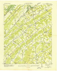
1936 Map of Big Ridge Park
USGS Topo · Published 1936About this map
Norris Reservoir dominates the northwestern landscape of this 1936 survey, illustrating the Tennessee Valley Authority’s transformation of the region through hydroelectric development. The creation of the reservoir led to the relocation of communities like Loyston, with this sheet marking the New Loyston Cem and reflecting the shift from valley-bottom farming to recreational and conservation uses. Big Ridge Park and Big Ridge Park Lake appear prominently, preserved as early TVA public lands during the Great Depression.
Find a feature on this map
80 named features on this map. Tap any name to fly to it.
Don’t see what you’re looking for? This feature index may not catch every label — zoom into the map to look around manually.
Map Details
Editions of this 1936 Big Ridge Park Map
This is the sole edition of this map. No revisions or reprints were ever made.
Other maps of this area

1893 · Briceville
USGS Topo · 1:125,000

1895 · Briceville
USGS Topo · 1:125,000

1896 · Briceville
USGS Topo · 1:125,000

1897 · Maynardville
USGS Topo · 1:125,000

1900 · Maynardville
USGS Topo · 1:125,000

1935 · Graveston
USGS Topo · 1:24,000

1935 · Fountain City
USGS Topo · 1:24,000

1936 · Gorryton
USGS Topo · 1:48,000

1936 · White Hollow
USGS Topo · 1:24,000
1936 · John Sevier
USGS Topo · 1:24,000