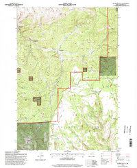
1995 Map of Big Rock Flat
USGS Topo · Published 1998About this map
Umatilla National Forest encompasses much of this landscape in Morrow County, characterized by a complex network of springs and canyons that defined early land use. This mid-1990s survey records a region where water sources like Morphine Spring, Opal Spring, and Hollywood Spring dictated the placement of trails and early industrial sites. The presence of Reeds Mill and Parkers Mill along the northern drainages highlights the area's timber history, while Big Rock Flat Airstrip suggests the logistical demands of managing this remote terrain. Family-named landmarks and geographic features such as Barlow Butte, Opal Butte, and Harris Canyon provide significant detail for genealogists tracing local history. The map also identifies the Anson Wright Memorial Park, a key community landmark near Fleming Spring, and numerous prospect sites that speak to the area's geological exploration and mining interests.
Find a feature on this map
61 named features on this map. Tap any name to fly to it.
Don’t see what you’re looking for? This feature index may not catch every label — zoom into the map to look around manually.
Map Details
Editions of this 1995 Big Rock Flat Map
This is the sole edition of this map. No revisions or reprints were ever made.
Other maps of this area

1951 · Monument
USGS Topo · 1:62,500

1953 · Kimberly
USGS Topo · 1:62,500

1953 · Pendleton
USGS Topo · 1:250,000

1955 · Canyon City
USGS Topo · 1:250,000

1956 · Pendleton
USGS Topo · 1:250,000

1959 · Canyon City
USGS Topo · 1:250,000

1969 · Summerfield Ridge
USGS Topo · 1:24,000

1969 · Chapin Creek
USGS Topo · 1:24,000

1969 · Madison Butte
USGS Topo · 1:24,000

1969 · Hardman
USGS Topo · 1:24,000