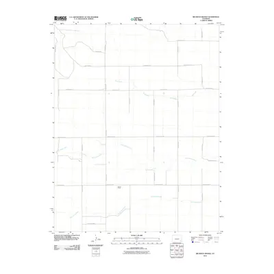
2010 Map of Big Rock Grange
USGS Topo · Published 2010About this map
Big Rock Grange centers this depiction of southeastern Colorado's high plains, where the land is defined by a rigorous section-line road grid and the meandering paths of intermittent waterways. The landscape is primarily shaped by the drainage systems of Sand Creek, North Horse Creek, and South Horse Creek, which cut through the open country. The road network, including arterial routes like County Road VV and County Road UU, illustrates the systematic land division characteristic of the region's agricultural and ranching heritage. This 2010 survey reflects a contemporary era of the high plains, where the primary infrastructure consists of these essential rural thoroughfares and the natural contours of the creek beds, providing a clear view of the area's geography before further modern development.
Find a feature on this map
19 named features on this map. Tap any name to fly to it.
Don’t see what you’re looking for? This feature index may not catch every label — zoom into the map to look around manually.
Map Details
Editions of this 2010 Big Rock Grange Map
This is the sole edition of this map. No revisions or reprints were ever made.
Other maps of this area

1891 · Springfield
USGS Topo · 1:125,000

1892 · Two Butte
USGS Topo · 1:125,000

1893 · Two Butte
USGS Topo · 1:125,000

1893 · Springfield
USGS Topo · 1:125,000

1955 · La Junta
USGS Topo · 1:250,000

1958 · La Junta
USGS Topo · 1:250,000

1968 · La Junta
USGS Topo · 1:250,000
1971 · Big Rock Grange
USGS Topo · 1:24,000
1971 · Horse Creek Springs
USGS Topo · 1:24,000
1971 · Mc Endree Ranch
USGS Topo · 1:24,000