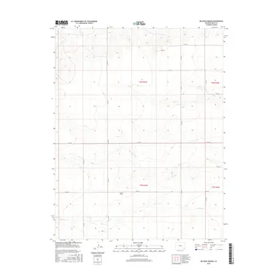
2016 Map of Big Rock Grange
USGS Topo · Published 2016About this map
Big Rock Grange stands as the central landmark of this high plains landscape in the southeastern corner of the state. The terrain is defined by a series of subtle drainage networks, including Sand Cr in the north and the parallel courses of N Horse Cr and S Horse Cr further south. These intermittent watercourses cut through a region organized by a rigid grid of rural roads, such as Co RD RR and Co RD 20. The map depicts the transition between Townships 28 South and 29 South, illustrating a late-modern era of agricultural land management where long-standing grange associations continue to anchor the community infrastructure amidst the open prairie.
Find a feature on this map
19 named features on this map. Tap any name to fly to it.
Don’t see what you’re looking for? This feature index may not catch every label — zoom into the map to look around manually.
Map Details
Editions of this 2016 Big Rock Grange Map
This is the sole edition of this map. No revisions or reprints were ever made.
Other maps of this area

1891 · Springfield
USGS Topo · 1:125,000

1892 · Two Butte
USGS Topo · 1:125,000

1893 · Two Butte
USGS Topo · 1:125,000

1893 · Springfield
USGS Topo · 1:125,000

1955 · La Junta
USGS Topo · 1:250,000

1958 · La Junta
USGS Topo · 1:250,000

1968 · La Junta
USGS Topo · 1:250,000
1971 · Big Rock Grange
USGS Topo · 1:24,000
1971 · Horse Creek Springs
USGS Topo · 1:24,000
1971 · Mc Endree Ranch
USGS Topo · 1:24,000