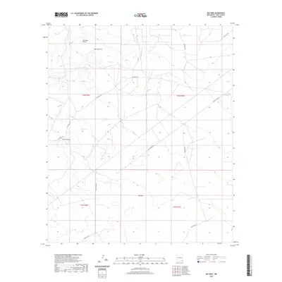
2020 Map of Big Sinks
USGS Topo · Published 2020About this map
Big Sinks characterizes the arid topography of this Eddy County landscape, where natural depressions and drainage systems dictate the layout of the land. In the northern reaches, Centinela Mound rises as a prominent landmark above Dog Town Draw, while the presence of Poker Tank, Poker Lake, and Windy Tank underscores the importance of water management in this high-desert environment. The region is etched with remote corridors such as Twin Wells Rd and McDonald Rd, which navigate the terrain near Pierce Canyon. This 2020 survey reveals a landscape defined by its ranching infrastructure and natural geology, showcasing the sparse network of rural roads like Buck Jackson Rd and Buckthorn Rd that cross the townships of the New Mexico interior.
Find a feature on this map
16 named features on this map. Tap any name to fly to it.
Don’t see what you’re looking for? This feature index may not catch every label — zoom into the map to look around manually.
Map Details
Editions of this 2020 Big Sinks Map
This is the sole edition of this map. No revisions or reprints were ever made.
Other maps of this area

1939 · Nash Draw
USGS Topo · 1:62,500

1943 · Nash Draw
USGS Topo · 1:62,500

1954 · Hobbs
USGS Topo · 1:250,000

1958 · Hobbs
USGS Topo · 1:250,000

1963 · Hat Mesa
USGS Topo · 1:62,500
1968 · Pierce Canyon
USGS Topo · 1:24,000

1968 · Phantom Banks
USGS Topo · 1:24,000
1968 · Big Sinks
USGS Topo · 1:24,000
1968 · Ross Ranch
USGS Topo · 1:24,000

1973 · Paduca Breaks NW
USGS Topo · 1:24,000