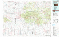
1993 Map of Big Snowy Mountains
USGS Topo · Published 1993About this map
Big Snowy Mountains dominate the central landscape of this 1993 study, anchored by the high elevations of Greathouse Peak and the prominent Knife Blade Ridge. This region of central Montana serves as a critical divide where the Lewis and Clark National Forest meets the surrounding high plains. The settlement pattern is defined by small railroad and ranching communities such as Judith Gap, Heath, and Buffalo, many of which follow the path of the Burlington Northern railroad. The map illustrates a complex drainage system where the Judith River and Flatwillow Creek collect water from numerous mountain forks and coulees. Notable geological landmarks like the Elephant Rocks and Castle Rocks rise from the foothills, while a series of elevated plateaus including McCartney Bench and Alaska Bench provide a distinct transition between the mountain peaks and the lower-elevation agriculture of the Ross Fork valley.
Find a feature on this map
62 named features on this map. Tap any name to fly to it.
Don’t see what you’re looking for? This feature index may not catch every label — zoom into the map to look around manually.
Map Details
Editions of this 1993 Big Snowy Mountains Map
This is the sole edition of this map. No revisions or reprints were ever made.
Other maps of this area

1886 · Little Belt Mts.
USGS Topo · 1:250,000

1889 · Big Snowy Mountain
USGS Topo · 1:250,000

1890 · Fort Benton
USGS Topo · 1:250,000

1892 · Fort Benton
USGS Topo · 1:250,000

1893 · Big Snowy Mountain
USGS Topo · 1:250,000

1894 · Little Belt Mts.
USGS Topo · 1:250,000

1897 · Fort Benton
USGS Topo · 1:250,000

1897 · Little Belt Mts.
USGS Topo · 1:250,000

1898 · Little Belt Mts.
USGS Topo · 1:250,000

1902 · Little Belt Mts.
USGS Topo · 1:250,000