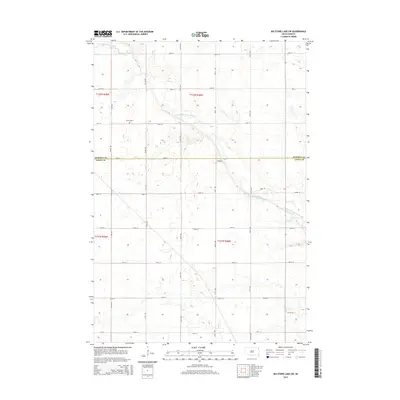
2015 Map of Big Stone Lake SW
USGS Topo · Published 2015About this map
The N Fork Whetstone River, also labeled as the North Fork Whetstone River, winds through this agricultural landscape in northeastern South Dakota. The terrain is defined by the survey grid of the Public Land Survey System, featuring township boundaries for t122n r49w, t122n r48w, t121n r49w, and t121n r48w. For those tracing local history, the Corona Cem sits as a primary landmark along 141st ST, serving as a silent anchor for the rural community. The map illustrates a strictly organized network of section-line roads, such as 139th ST through 147th ST, showing the persistent structure of the High Plains prairie decades after initial settlement. The boundary between Roberts and Grant Counties bisects the northern half of the sheet, providing a precise record of local jurisdiction and property division.
Find a feature on this map
18 named features on this map. Tap any name to fly to it.
Don’t see what you’re looking for? This feature index may not catch every label — zoom into the map to look around manually.
Map Details
Editions of this 2015 Big Stone Lake SW Map
This is the sole edition of this map. No revisions or reprints were ever made.
Other maps of this area

1953 · Milbank
USGS Topo · 1:250,000

1954 · Big Stone Lake
USGS Topo · 1:62,500

1958 · Milbank
USGS Topo · 1:250,000

1971 · Big Stone Lake East
USGS Topo · 1:24,000

1971 · Corona
USGS Topo · 1:24,000

1971 · Big Stone Lake West
USGS Topo · 1:24,000

1971 · Big Stone Lake SE
USGS Topo · 1:24,000

1971 · Big Stone Lake SW
USGS Topo · 1:24,000
1971 · Wilmot
USGS Topo · 1:24,000

1973 · Twin Brooks
USGS Topo · 1:24,000