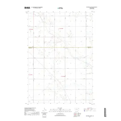
2017 Map of Big Stone Lake SW
USGS Topo · Published 2017About this map
The town of Corona anchors the northwestern corner of this 2017 survey, situated near the boundary between Roberts and Grant counties. This agricultural landscape is defined by the winding course of the North Fork Whetstone River, which flows through the eastern half of the quadrangle. The map reveals a highly structured grid of section lines and rural routes, including Co Hwy 2 and Co Hwy 21, which facilitate movement through the farming communities of the Coteau des Prairies region. For those tracing local history or genealogy, the Kilborn Lutheran Cem serves as a significant landmark along 142nd St. The abundance of wetlands and small basins throughout the terrain indicates the glacial legacy of this part of South Dakota, where the interplay of water and elevation continues to shape land use and local development.
Find a feature on this map
26 named features on this map. Tap any name to fly to it.
Don’t see what you’re looking for? This feature index may not catch every label — zoom into the map to look around manually.
Map Details
Editions of this 2017 Big Stone Lake SW Map
This is the sole edition of this map. No revisions or reprints were ever made.
Other maps of this area

1953 · Milbank
USGS Topo · 1:250,000

1954 · Big Stone Lake
USGS Topo · 1:62,500

1958 · Milbank
USGS Topo · 1:250,000

1971 · Big Stone Lake East
USGS Topo · 1:24,000

1971 · Corona
USGS Topo · 1:24,000

1971 · Big Stone Lake West
USGS Topo · 1:24,000

1971 · Big Stone Lake SE
USGS Topo · 1:24,000

1971 · Big Stone Lake SW
USGS Topo · 1:24,000
1971 · Wilmot
USGS Topo · 1:24,000

1973 · Twin Brooks
USGS Topo · 1:24,000