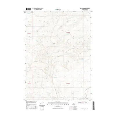
2015 Map of Big Sulfur Draw
USGS Topo · Published 2015About this map
Big Sulfur Spring and the namesake drainage of Big Sulfur Draw dominate this high plains landscape in Natrona County. This arid region is defined by its complex network of seasonal water management and distinctive topography, where numerous catchments such as Suicide Reservoir, Alkali Reservoir, and the Suicide Bed Grounds Reservoir illustrate the vital importance of water storage for ranching. The terrain is deeply incised by erosion, most notably at Stone and Timber Draw and Ellis Draw, which channel runoff toward the S Fork Powder River in the southeast corner. Local travel is anchored by Thirty-Three Mile Rd in the north, providing a rare traversable route through a landscape of broken ridges and dry creek beds like Lone Bear Cr.
Find a feature on this map
21 named features on this map. Tap any name to fly to it.
Don’t see what you’re looking for? This feature index may not catch every label — zoom into the map to look around manually.
Map Details
Editions of this 2015 Big Sulfur Draw Map
This is the sole edition of this map. No revisions or reprints were ever made.
Other maps of this area

1955 · Arminto
USGS Topo · 1:250,000

1958 · Arminto
USGS Topo · 1:250,000

1962 · Arminto
USGS Topo · 1:250,000

1968 · Willow Creek School
USGS Topo · 1:24,000

1968 · Roughlock Hill
USGS Topo · 1:24,000

1968 · Reynolds Reservoir
USGS Topo · 1:24,000

1968 · Big Sulfur Draw
USGS Topo · 1:24,000

1968 · Fiftymile Flat
USGS Topo · 1:24,000
1968 · Anderson Draw
USGS Topo · 1:24,000

1968 · Flat Top Hill
USGS Topo · 1:24,000