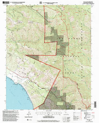
1995 Map of Big Sur
USGS Topo · Published 2000About this map
Pico Blanco dominates the central topography of this coastal Monterey County region, where the Santa Lucia Range meets the Pacific Ocean. This 1995 revision, based on imagery from the early 1990s, documents a landscape largely defined by public conservation and recreation areas, including Andrew Molera State Park and Pfeiffer Big Sur State Park. The map reveals the intricate network of backcountry trails and campsites, such as the Pico Blanco Boy Scout Camp and Apple Tree Campsite, that characterize the Ventana Wilderness.
Find a feature on this map
71 named features on this map. Tap any name to fly to it.
Don’t see what you’re looking for? This feature index may not catch every label — zoom into the map to look around manually.
Map Details
Editions of this 1995 Big Sur Map
This is the sole edition of this map. No revisions or reprints were ever made.
Other maps of this area

1918 · Point Sur
USGS Topo · 1:62,500

1920 · Jamesburg
USGS Topo · 1:48,000

1921 · Jamesburg
USGS Topo · 1:62,500

1921 · Lucia
USGS Topo · 1:62,500

1925 · Point Sur
USGS Topo · 1:62,500

1939 · Jamesburg
USGS Topo · 1:62,500

1940 · Jamesburg
USGS Topo · 1:62,500

1941 · Lucia
USGS Topo · 1:62,500

1947 · Lucia
USGS Topo · 1:62,500

1947 · Jamesburg
USGS Topo · 1:62,500