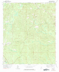
1971 Map of Bigbee
USGS Topo · Published 1984About this map
Bigbee and the surrounding rural landscape of Washington County appear here as they were documented in the early 1970s. The area is defined by its complex drainage network, where the North Prong, Middle Prong, and South Prong of Tauler Creek converge. These waterways, along with the expansive Bull Hall Swamp to the south, dictate the placement of small settlements and historical transit routes across the interior of the county.
Find a feature on this map
28 named features on this map. Tap any name to fly to it.
Don’t see what you’re looking for? This feature index may not catch every label — zoom into the map to look around manually.
Map Details
Editions of this 1971 Bigbee Map
2 editions found
Other maps of this area

1943 · McIntosh
USGS Topo · 1:62,500

1944 · McIntosh
USGS Topo · 1:62,500

1953 · Hattiesburg
USGS Topo · 1:250,000

1958 · Hattiesburg
USGS Topo · 1:250,000

1971 · Bigbee
USGS Topo · 1:24,000

1971 · Bladon Springs
USGS Topo · 1:24,000

1972 · Tattlersville
USGS Topo · 1:24,000

1972 · St. Stephens
USGS Topo · 1:24,000

1974 · Millry South
USGS Topo · 1:24,000

1974 · Chatom
USGS Topo · 1:24,000