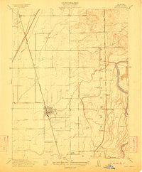
1912 Map of Biggs
USGS Topo · Published 1912About this map
Agricultural development in Butte County is clearly defined in this early twentieth-century survey, centered on the grid of Biggs. The landscape is governed by a sophisticated network of water management, with the Cherokee Canal, Butte City Canal, and Fleming Ditch cutting across the flat valley floor toward the Feather River. This period shows the transition of the region into a major rice and grain producer, supported by dual rail lines. The Southern Pacific RR (Marysville Line) passes through Richvale and Biggs, while the Northern Electric RR serves smaller sidings like Haselbusch and Hume. Local life is anchored by landmarks such as the River District School and the Live Oak Cemetery, providing essential data points for genealogists and local historians tracking the early families of this Sacramento Valley community.
Find a feature on this map
17 named features on this map. Tap any name to fly to it.
Don’t see what you’re looking for? This feature index may not catch every label — zoom into the map to look around manually.
Map Details
Editions of this 1912 Biggs Map
This is the sole edition of this map. No revisions or reprints were ever made.
Other maps of this area

1888 · Marysville
USGS Topo · 1:125,000

1891 · Chico
USGS Topo · 1:125,000

1891 · Marysville
USGS Topo · 1:125,000

1893 · Chico
USGS Topo · 1:125,000

1894 · Marysville
USGS Topo · 1:125,000

1895 · Marysville
USGS Topo · 1:125,000

1895 · Chico
USGS Topo · 1:125,000

1911 · Landlow
USGS Topo · 1:31,680

1912 · Dry Creek
USGS Topo · 1:31,680

1912 · Oroville
USGS Topo · 1:31,680