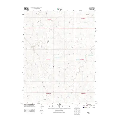
2013 Map of Bijou
USGS Topo · Published 2013About this map
Middle Bijou Creek carves a path through this section of Elbert County, defining a landscape of high plains drainage and dry gulches. The small settlement of Bijou sits at the center of a network of county roads, including CO Road 154 and CO Road 158, reflecting the area's rural agricultural character. To the south, the Gair Cemetery remains a significant touchstone for local family history and genealogy. Water management is a primary feature of the local topography, evidenced by several containment structures such as the Frank Ehman Detention Reservoir and Shirley Detention Reservoir Number 1. This 2013 survey illustrates the modern configuration of ranching and residential tracts, identified by a system of gemstone-themed roads like Amethyst Road and Sapphire Trail in the western reaches.
Find a feature on this map
34 named features on this map. Tap any name to fly to it.
Don’t see what you’re looking for? This feature index may not catch every label — zoom into the map to look around manually.
Map Details
Editions of this 2013 Bijou Map
This is the sole edition of this map. No revisions or reprints were ever made.
Other maps of this area
1953 · Denver
USGS Topo · 1:250,000
1957 · Denver
USGS Topo · 1:250,000
1958 · Denver
USGS Topo · 1:250,000
1960 · Denver
USGS Topo · 1:250,000
1968 · Deer Trail
USGS Topo · 1:24,000
1969 · Strasburg SE
USGS Topo · 1:24,000
1969 · Deer Trail
USGS Topo · 1:24,000
1969 · Byers SW
USGS Topo · 1:24,000
1970 · Kiowa NE
USGS Topo · 1:24,000
1970 · Big Gulch
USGS Topo · 1:24,000