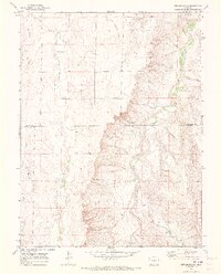
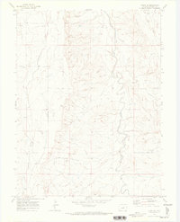
1969 Map of Strasburg SE
USGS Topo · Published 1973About this map
The county boundary between Arapahoe Co and Elbert Co bisects this late-1960s landscape, which is defined by a series of parallel north-flowing drainage systems. The terrain transitions from the broader valley of West Bijou Creek in the east to the more dissected uplands near Wolf Creek and Comanche Creek in the west. This period captures the rural character of the high plains before significant suburban expansion, showing a landscape utilized for resource extraction and utility infrastructure. Notable evidence of local industry and development includes a Gravel Pit near the northern edge and a prominent Pipeline that cuts across the northern and eastern sections of the quadrangle. Other smaller watercourses, such as Lone Tree Gulch, East Gulch, and Mule Gulch, illustrate the complex drainage patterns that shaped local land use and property boundaries during this era.
Find a feature on this map
10 named features on this map. Tap any name to fly to it.
Don’t see what you’re looking for? This feature index may not catch every label — zoom into the map to look around manually.
Map Details
Editions of this 1969 Strasburg SE Map
2 editions found
Other maps of this area

1953 · Denver
USGS Topo · 1:250,000

1955 · Strasburg NW
USGS Topo · 1:24,000

1955 · Strasburg
USGS Topo · 1:24,000

1956 · Byers
USGS Topo · 1:24,000

1957 · Denver
USGS Topo · 1:250,000

1958 · Denver
USGS Topo · 1:250,000

1960 · Denver
USGS Topo · 1:250,000
1961 · Strasburg SW
USGS Topo · 1:24,000
1969 · Byers SW
USGS Topo · 1:24,000
1970 · Kiowa NE
USGS Topo · 1:24,000