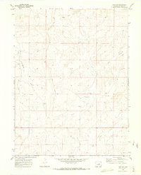
1970 Map of Bijou SW
USGS Topo · Published 1973About this map
Middle Bijou Creek and East Bijou Creek carve a network of drainages across this Elbert County landscape, defining the local ranching and transit patterns of the late 1960s. The presence of Brittingham Ranch, complete with its own Landing Strips, illustrates the importance of private aviation in navigating this expansive territory. A cluster of infrastructure appears near the settlement of Minter, including a Radio Facility, while the Norton Cem serves as a silent point of genealogical interest along the western hills. The terrain is marked by significant features like Spring Gulch and Wilson Creek, which are connected by a system of rural routes such as Ridge Road. This topographic survey provides a detailed look at the interface between traditional livestock ranching and modern utility development in the High Plains.
Find a feature on this map
14 named features on this map. Tap any name to fly to it.
Don’t see what you’re looking for? This feature index may not catch every label — zoom into the map to look around manually.
Map Details
Editions of this 1970 Bijou SW Map
2 editions found
Other maps of this area

1953 · Denver
USGS Topo · 1:250,000

1957 · Denver
USGS Topo · 1:250,000

1958 · Denver
USGS Topo · 1:250,000

1960 · Denver
USGS Topo · 1:250,000
1970 · Kiowa NE
USGS Topo · 1:24,000

1970 · Big Gulch
USGS Topo · 1:24,000
1970 · Cattle Gulch
USGS Topo · 1:24,000
1970 · Fondis
USGS Topo · 1:24,000
1970 · Bijou
USGS Topo · 1:24,000
1970 · Ramah North
USGS Topo · 1:24,000