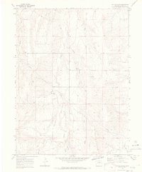
1970 Map of Cattle Gulch
USGS Topo · Published 1973About this map
Middle Bijou Creek and Wilson Creek carve through this landscape in Elbert County, creating a series of north-trending ridges and drainage basins typical of the high plains. The topography, based on 1968 aerial photography and field-checked in 1970, reveals a sparsely settled region primarily defined by its hydrology and minor extractive activities. A prominent Pipeline traverses the central terrain, while small-scale industrial sites like Gravel Pits and a Drill Hole suggest local mineral exploration and material sourcing. The dominance of features like Cattle Gulch and Bland Creek highlights the importance of water management in this environment. Scattered Wells across the sheet underscore the infrastructure required to sustain the cattle-grazing economy of the era. This survey provides a look at the transition between the rolling uplands and the drainage systems feeding into the larger Bijou Creek watershed.
Find a feature on this map
10 named features on this map. Tap any name to fly to it.
Don’t see what you’re looking for? This feature index may not catch every label — zoom into the map to look around manually.
Map Details
Editions of this 1970 Cattle Gulch Map
4 editions found
Other maps of this area

1891 · Limon
USGS Topo · 1:125,000

1892 · Limon
USGS Topo · 1:125,000

1953 · Denver
USGS Topo · 1:250,000

1954 · Limon
USGS Topo · 1:250,000

1957 · Denver
USGS Topo · 1:250,000

1957 · Limon
USGS Topo · 1:250,000

1958 · Limon
USGS Topo · 1:250,000

1958 · Denver
USGS Topo · 1:250,000

1960 · Denver
USGS Topo · 1:250,000

1968 · Deer Trail
USGS Topo · 1:24,000