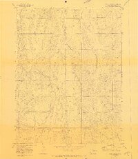
1970 Map of Cattle Gulch
USGS Topo · Published 1973About this map
The drainage patterns of the High Plains are clearly defined in this 1970 landscape, where the seasonal flow of Middle Bijou Creek and East Bijou Creek carves through the undulating terrain. The area's character is fundamentally shaped by these watercourses, including Cattle Gulch and Wilson Creek, which provide the primary relief in an otherwise expansive plains environment. The map captures the quiet infrastructure of the period, notably the long diagonal stretch of a Pipeline and the presence of scattered industrial markers such as a Drill Hole and several Gravel Pits. This survey reflects a moment of sparse development, with human presence marked primarily by rural wells and the management of water resources in the ranchlands of Elbert County.
Find a feature on this map
10 named features on this map. Tap any name to fly to it.
Don’t see what you’re looking for? This feature index may not catch every label — zoom into the map to look around manually.
Map Details
Editions of this 1970 Cattle Gulch Map
4 editions found
Other maps of this area

1891 · Limon
USGS Topo · 1:125,000

1892 · Limon
USGS Topo · 1:125,000

1953 · Denver
USGS Topo · 1:250,000

1954 · Limon
USGS Topo · 1:250,000

1957 · Denver
USGS Topo · 1:250,000

1957 · Limon
USGS Topo · 1:250,000

1958 · Limon
USGS Topo · 1:250,000

1958 · Denver
USGS Topo · 1:250,000

1960 · Denver
USGS Topo · 1:250,000

1968 · Deer Trail
USGS Topo · 1:24,000