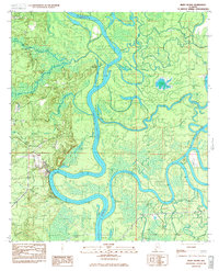
1983 Map of Bilbo Island
USGS Topo · Published 1983About this map
The confluence of the Tombigbee River and the Alabama River defines this landscape, where the two great waterways merge to form the headwaters of the Mobile River. This 1983 survey captures a complex delta environment of islands and overflow lakes at the meeting point of Baldwin, Mobile, Clarke, and Washington Counties. The terrain is dominated by Bilbo Island and a network of backwater features like Poll Bayou, Bilbo Lake, and the curiously named Hellcat Lake.
Find a feature on this map
23 named features on this map. Tap any name to fly to it.
Don’t see what you’re looking for? This feature index may not catch every label — zoom into the map to look around manually.
Map Details
Editions of this 1983 Bilbo Island Map
2 editions found
Other maps of this area

1943 · Choctaw Bluff
USGS Topo · 1:62,500

1943 · Tensaw
USGS Topo · 1:62,500

1943 · Citronelle
USGS Topo · 1:62,500

1943 · McIntosh
USGS Topo · 1:62,500

1944 · McIntosh
USGS Topo · 1:62,500

1944 · Tensaw
USGS Topo · 1:62,500

1946 · Citronelle
USGS Topo · 1:62,500

1946 · Choctaw Bluff
USGS Topo · 1:62,500

1953 · Andalusia
USGS Topo · 1:250,000

1953 · Hattiesburg
USGS Topo · 1:250,000