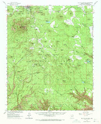
1962 Map of Bill Williams Mtn
USGS Topo · Published 1971About this map
Williams serves as the gateway to the high plateau country of the Kaibab National Forest, where the Atchison Topeka and Santa Fe railway charts a course across the northern territory. This early 1960s landscape is defined by its water management and livestock history, featuring a network of essential catchments like Dogtown Reservoir, Saginaw Reservoirs, and Santa Fe Res. The presence of several named ranches, including Benham Ranch and Shiner Ranch, alongside numerous livestock tanks such as Bowdon Tank and May Tank, indicates the enduring grazing economy of the Coconino high country.
Find a feature on this map
65 named features on this map. Tap any name to fly to it.
Don’t see what you’re looking for? This feature index may not catch every label — zoom into the map to look around manually.
Map Details
Editions of this 1962 Bill Williams Mtn Map
3 editions found
Other maps of this area

1886 · San Francisco Mtns
USGS Topo · 1:250,000

1886 · Chino
USGS Topo · 1:250,000

1887 · Verde
USGS Topo · 1:250,000

1887 · Prescott
USGS Topo · 1:250,000

1891 · San Francisco Mtns
USGS Topo · 1:250,000

1891 · Chino
USGS Topo · 1:250,000

1892 · Verde
USGS Topo · 1:250,000

1892 · Prescott
USGS Topo · 1:250,000

1894 · San Francisco Mtns
USGS Topo · 1:250,000

1899 · San Francisco Mtns
USGS Topo · 1:250,000