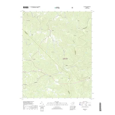
2019 Map of Billows
USGS Topo · Published 2019About this map
The Rockcastle River carves a deep path through the eastern reaches of this Pulaski County landscape, defining the jagged boundaries shared with Laurel and Rockcastle counties. Within the Daniel Boone National Forest, the terrain is a complex network of high ridges and hollows, including Kincade Ridge, Dugar Ridge, and Cromer Ridge. These uplands separate local drainages like Skegg Cr and Line Cr. Small, rural settlements such as Squib, Billows, and Conrard are connected by a web of forest and county roads, including Public Rd and Sand Springs Rd. For the local historian, the map preserves the locations of several family landmarks, notably Phelps Cem, Bustle Cem, and two sites marked Whitaker Cem, alongside the remote Chestnut Knolls Airport near Angel Hollow.
Find a feature on this map
65 named features on this map. Tap any name to fly to it.
Don’t see what you’re looking for? This feature index may not catch every label — zoom into the map to look around manually.
Map Details
Editions of this 2019 Billows Map
This is the sole edition of this map. No revisions or reprints were ever made.
Other maps of this area

1893 · London
USGS Topo · 1:125,000

1897 · London
USGS Topo · 1:125,000

1952 · London SW
USGS Topo · 1:24,000

1952 · Billows
USGS Topo · 1:24,000

1952 · Ano
USGS Topo · 1:24,000

1952 · Dykes
USGS Topo · 1:24,000

1952 · Shopville
USGS Topo · 1:24,000

1952 · Bernstadt
USGS Topo · 1:24,000

1953 · Maretburg
USGS Topo · 1:24,000

1953 · Livingston
USGS Topo · 1:24,000