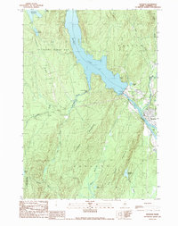
1989 Map of Bingham
USGS Topo · Published 1989About this map
The Kennebec River corridor dominates this Somerset County landscape, shaped by the industrial infrastructure of the late twentieth century. Central to the area is the Wyman Dam, a large Conc Dam installation featuring a Hydroelectric Plant, Flood Gates, and a Substa that regulates the expansive Wyman Lake. The settlements of Bingham and Moscow sit at the southern end of this reservoir system, where the river narrows and passes the prominent Big Island.
Find a feature on this map
37 named features on this map. Tap any name to fly to it.
Don’t see what you’re looking for? This feature index may not catch every label — zoom into the map to look around manually.
Map Details
Editions of this 1989 Bingham Map
This is the sole edition of this map. No revisions or reprints were ever made.
Other maps of this area

1903 · Bingham
USGS Topo · 1:62,500

1904 · Anson
USGS Topo · 1:62,500

1905 · Bingham
USGS Topo · 1:62,500

1928 · Dead River
USGS Topo · 1:62,500

1930 · Kingfield
USGS Topo · 1:48,000

1931 · Dead River
USGS Topo · 1:48,000

1932 · Kingfield
USGS Topo · 1:62,500

1944 · Dead River
USGS Topo · 1:62,500

1948 · Bangor
USGS Topo · 1:250,000

1949 · Jackman
USGS Topo · 1:250,000