
Loading...
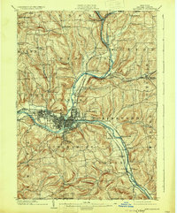
Loading map...1948 Map of Binghamton
USGS Topo · Published 1980About this map
The Susquehanna River and Chenango River converge at Binghamton, the industrial and transportation anchor of New York's Southern Tier during the mid-twentieth century. This survey reveals a landscape defined by the deep valleys of the Catskill Mountains and the strategic rail corridors that connected them. The Erie Railroad and the Delaware and Hudson RR parallel the major waterways, servicing manufacturing centers in Johnson City and Endicott.
Find a feature on this map
120 named features on this map. Tap any name to fly to it.
Don’t see what you’re looking for? This feature index may not catch every label — zoom into the map to look around manually.
Map Details
Date Portrayed1948
Date Published1980
PublisherU.S. Geological Survey
Map TypeTopographic
Scale1:250,000
Physical Dimensions29 x 24.2 inches
Editions of this 1948 Binghamton Map
This is the sole edition of this map. No revisions or reprints were ever made.
Historical Maps of Union Through Time
6 maps found


Featured Locations
Source Details
SourceU.S. Geological Survey
CopyrightPublic Domain