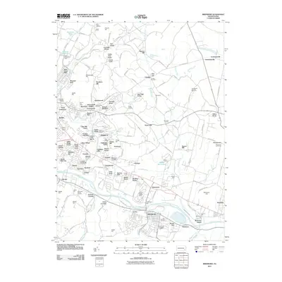
2010 Map of Birdsboro
USGS Topo · Published 2010About this map
Monocacy Creek and the Schuylkill River define the lower reaches of this Berks County landscape, where industrial heritage and modern residential expansion meet. The map reveals a dense network of milling sites along these waterways, including Beavers Mill, Browns Mill, and Flannery Mill, which hint at the region's historic reliance on water power. To the southeast, the borough of Birdsboro stands near the river, surrounded by sites of local historical significance such as the Jean Bertolet Memorial Monument and Boonecroft.
Find a feature on this map
178 named features on this map. Tap any name to fly to it.
Don’t see what you’re looking for? This feature index may not catch every label — zoom into the map to look around manually.
Map Details
Editions of this 2010 Birdsboro Map
This is the sole edition of this map. No revisions or reprints were ever made.
Other maps of this area

1894 · Reading
USGS Topo · 1:62,500

1902 · Boyertown
USGS Topo · 1:62,500

1905 · Honey Brook
USGS Topo · 1:62,500

1906 · Phoenixville
USGS Topo · 1:62,500

1907 · Honeybrook
USGS Topo · 1:62,500

1913 · Reading
USGS Topo · 1:62,500

1915 · Reading
USGS Topo · 1:62,500

1941 · Honeybrook
USGS Topo · 1:62,500

1943 · Manatawny
USGS Topo · 1:31,680
1943 · Boyertown
USGS Topo · 1:31,680
Featured Places
- Birdsboro, PA
- Oley Township, PA
- Village of Jacksonwald, Exeter Township
- Alsace Township, PA
- Browns Mill, Amity Township