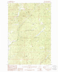
1985 Map of Bison Canyon
USGS Topo · Published 1986About this map
Deerlodge National Forest dominates this mid-1980s terrain in Jefferson County, where the high-altitude landscape is shaped by deep drainages and legacy industrial activity. The western edge of the map is defined by Elk Park and the distinct path of an Old Railroad Grade that follows the course of Bison Creek through the steep-walled Bison Canyon. This corridor provides a clear record of historical transportation routes through the mountains before modern realignments.
Find a feature on this map
39 named features on this map. Tap any name to fly to it.
Don’t see what you’re looking for? This feature index may not catch every label — zoom into the map to look around manually.
Map Details
Editions of this 1985 Bison Canyon Map
This is the sole edition of this map. No revisions or reprints were ever made.
Other maps of this area

1889 · Helena
USGS Topo · 1:250,000

1893 · Helena
USGS Topo · 1:250,000

1899 · Boulder
USGS Topo · 1:125,000

1899 · Helena
USGS Topo · 1:250,000

1903 · Helena
USGS Topo · 1:250,000

1947 · Butte
USGS Topo · 1:250,000

1950 · Jefferson City
USGS Topo · 1:62,500

1954 · Elk Park
USGS Topo · 1:62,500

1954 · Basin
USGS Topo · 1:62,500

1954 · Boulder
USGS Topo · 1:62,500