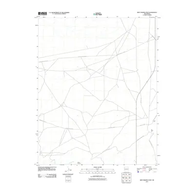
2010 Map of Bisti Trading Post
USGS Topo · Published 2010About this map
The Bisti Trading Post serves as the focal point for this high-desert landscape on the Chaco Plateau, where a network of Bureau of Indian Affairs and local roads converge. The geography is defined by the seasonal drainage of Hunter Wash, which cuts across the southern portion of the quadrangle. The map documents the infrastructure of the Shiprock Agency region in the early 21st century, centered on the commerce and community services provided by the trading post and the nearby Bisti Clinic. This area is characterized by vast open spaces and a road system that includes Indian Service Route 5 and Indian Service Route 5080, reflecting the importance of these thoroughfares in connecting the remote settlements of the Navajo Nation. Researchers can trace the modern development of these corridors and their relationship to traditional landmarks and natural watercourses.
Find a feature on this map
10 named features on this map. Tap any name to fly to it.
Don’t see what you’re looking for? This feature index may not catch every label — zoom into the map to look around manually.
Map Details
Editions of this 2010 Bisti Trading Post Map
This is the sole edition of this map. No revisions or reprints were ever made.
Other maps of this area

1889 · Chaco
USGS Topo · 1:250,000

1892 · Chaco
USGS Topo · 1:250,000

1927 · Sulphur Spring
USGS Topo · 1:96,000

1928 · Kirtland
USGS Topo · 1:125,000

1932 · Kirtland
USGS Topo · 1:125,000

1954 · Shiprock
USGS Topo · 1:250,000

1958 · Shiprock
USGS Topo · 1:250,000

1959 · Shiprock
USGS Topo · 1:250,000
1966 · Tanner Lake
USGS Topo · 1:24,000
1966 · Alamo Mesa West
USGS Topo · 1:24,000
Featured Places
- Shiprock Agency
- Eastern Navajo Agency, NM
- Bisti, Eastern Navajo Agency
- San Juan County, NM
- United States