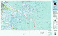
1983 Map of Black Bay
USGS Topo · Published 1983About this map
The Mississippi River defines the western edge of this 1983 topographic-bathymetric survey, where riverbank settlements like Chalmette, Violet, and Poydras transition into the expansive marshes of the Mississippi Delta. The landscape is a complex network of bayous and lagoons, including Black Bay, Eloi Bay, and Lake Coquille, reflecting the delicate balance between land and water. The arrival of the Mississippi River-Gulf Outlet Canal creates a sharp linear division through the wetlands, illustrating late 20th-century maritime engineering efforts to bypass the traditional river route.
Find a feature on this map
195 named features on this map. Tap any name to fly to it.
Don’t see what you’re looking for? This feature index may not catch every label — zoom into the map to look around manually.
Map Details
Editions of this 1983 Black Bay Map
2 editions found
Other maps of this area

1891 · Spanish Fort
USGS Topo · 1:62,500

1891 · Pointe a La Hache
USGS Topo · 1:62,500

1891 · New Orleans
USGS Topo · 1:62,500

1892 · Barataria
USGS Topo · 1:62,500

1892 · Chef Menteur
USGS Topo · 1:62,500

1892 · Quarantine
USGS Topo · 1:62,500

1892 · Creole
USGS Topo · 1:62,500

1892 · St. Bernard
USGS Topo · 1:62,500

1892 · Pointe a La Hache
USGS Topo · 1:62,500

1893 · Cat Island
USGS Topo · 1:62,500