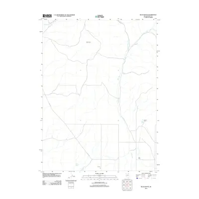
2012 Map of Black Butte
USGS Topo · Published 2012About this map
Black Butte rises as the central topographic landmark in this high-desert region of Elko County, where the landscape is defined by a network of seasonal water sources and isolated ranching outposts. The drainage pattern is anchored by the southward flow of Burnt Creek and its tributary, North Fork Burnt Creek, which cut through the arid terrain. Human presence in this corner of Nevada is tied to the availability of water, evidenced by the cluster of named springs including Antelope Springs and West Antelope Spring. Travel through this area relies on a sparse network of unpaved routes, such as the Oneil-Deeth Rd and Co Rd 754, which connect scattered homesteads like Thurston Ranch, Uhlig Ranch, and the CD Ranch. This 2012 survey illustrates the enduring ranching character of the Great Basin, where named family holdings remain the primary markers of settlement across the wide open range.
Find a feature on this map
12 named features on this map. Tap any name to fly to it.
Don’t see what you’re looking for? This feature index may not catch every label — zoom into the map to look around manually.
Map Details
Editions of this 2012 Black Butte Map
This is the sole edition of this map. No revisions or reprints were ever made.
Other maps of this area

1955 · Wells
USGS Topo · 1:250,000

1958 · Wells
USGS Topo · 1:250,000

1961 · Wells
USGS Topo · 1:250,000

1967 · Black Butte SW
USGS Topo · 1:24,000

1967 · Black Butte
USGS Topo · 1:24,000

1967 · Buena Vista Ranch
USGS Topo · 1:24,000

1967 · Black Butte NE
USGS Topo · 1:24,000

1967 · Metropolis
USGS Topo · 1:24,000
1967 · Tabor Flats
USGS Topo · 1:24,000

1968 · Summer Camp
USGS Topo · 1:24,000