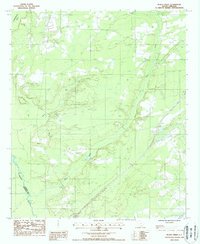
1988 Map of Black Creek
USGS Topo · Published 1988About this map
The Combahee River and its intricate network of tributaries define the Lowcountry landscape of Colleton County in the late 1980s. This survey documents the convergence of significant waterways, including the L Salkehatchie River and the winding course of Black Creek. The terrain is marked by seasonal drainage patterns evidenced by Bull Run and Sandy Run, which cut through the coastal plain. Human presence is sparse but distinct, indicated by a lone Fire Tower standing watch over the timberlands and a rural Cem located near the headwaters of the local runs. Modern infrastructure and land management are visible through the inclusion of Sewage Stabilization facilities and established Rest Areas along the primary transit corridor, reflecting the area's development as it balanced traditional river-bottom geography with late-twentieth-century utility requirements.
Find a feature on this map
12 named features on this map. Tap any name to fly to it.
Don’t see what you’re looking for? This feature index may not catch every label — zoom into the map to look around manually.
Map Details
Editions of this 1988 Black Creek Map
This is the sole edition of this map. No revisions or reprints were ever made.
Other maps of this area

1918 · Walterboro
USGS Topo · 1:62,500

1918 · Green Pond
USGS Topo · 1:62,500

1918 · Yemassee
USGS Topo · 1:62,500

1919 · Cummings
USGS Topo · 1:62,500

1943 · Yemassee
USGS Topo · 1:62,500

1943 · Green Pond
USGS Topo · 1:62,500

1943 · Cummings
USGS Topo · 1:62,500

1943 · Walterboro
USGS Topo · 1:62,500

1947 · Savannah
USGS Topo · 1:250,000

1948 · Savannah
USGS Topo · 1:250,000