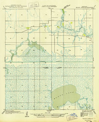
1949 Map of Black Lake
USGS Topo · Published 1949About this map
The expansive Black Lake dominates the southern reaches of this survey, illustrating the low-lying marshlands of southwest Louisiana during the early 20th century. Established through field examinations in 1932, the map documents a transition in the landscape as the Intracoastal Waterway cuts a straight path through the wetlands, dividing Calcasieu Parish from Cameron Parish. The network of water bodies, including Bayou Choupique and the secluded Goose Lake, reveals a complex hydrology before significant modern developments. This advance sheet captures the region's character as a coastal wilderness defined by its bayous and shallow lakes, providing an essential record for those studying the evolution of parish boundaries and the industrial impact of major canal projects on the natural marsh ecosystem.
Find a feature on this map
5 named features on this map. Tap any name to fly to it.
Don’t see what you’re looking for? This feature index may not catch every label — zoom into the map to look around manually.
Map Details
Editions of this 1949 Black Lake Map
This is the sole edition of this map. No revisions or reprints were ever made.
Other maps of this area

1932 · Moss Lake
USGS Topo · 1:31,680

1932 · Orange
USGS Topo · 1:62,500

1934 · Browns Lake
USGS Topo · 1:24,000

1934 · Five Lakes
USGS Topo · 1:24,000

1935 · Five Lakes
USGS Topo · 1:31,680

1935 · Hackberry
USGS Topo · 1:31,680

1935 · Browns Lake
USGS Topo · 1:31,680

1946 · Moss Lake
USGS Topo · 1:31,680

1947 · Sulphur
USGS Topo · 1:31,680

1947 · Vinton
USGS Topo · 1:31,680