
1934 Map of Five Lakes
USGS Topo · Published 1961About this map
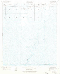
Five Lakes dominates this coastal landscape in Cameron Parish, where a complex network of marshland and waterways defined local life in the mid-1930s. The area is characterized by drainage and navigation projects such as the North Canal and Willow Bayou Canal, reflecting efforts to manage the low-lying terrain. Human presence is centered around recreational and seasonal outposts, most notably Stacks Hill Camp and the Orange-Cameron Co Club House, suggesting the importance of fishing and hunting to the local economy and culture.
Find a feature on this map
12 named features on this map. Tap any name to fly to it.
Don’t see what you’re looking for? This feature index may not catch every label — zoom into the map to look around manually.
Map Details
Editions of this 1934 Five Lakes Map
2 editions found
Other maps of this area

1932 · Orange
USGS Topo · 1:62,500

1934 · Johnsons Bayou
USGS Topo · 1:24,000

1934 · Holly Beach
USGS Topo · 1:24,000

1934 · Peveto Beach
USGS Topo · 1:24,000

1934 · Greens Bayou
USGS Topo · 1:24,000

1934 · Browns Lake
USGS Topo · 1:24,000

1935 · Peveto Beach
USGS Topo · 1:31,680

1935 · Five Lakes
USGS Topo · 1:31,680

1935 · Holly Beach
USGS Topo · 1:31,680

1935 · Browns Lake
USGS Topo · 1:31,680