
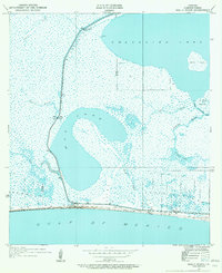
1934 Map of Holly Beach
USGS Topo · Published 1955About this map
Holly Beach sits at the narrow threshold between the vast marshlands of Cameron Parish and the open Gulf of Mexico. Surveyed in the mid-1930s, this landscape is defined by the complex hydrology of the Chenier Plain, where freshwater bayous meet the tidal influence of Calcasieu Lake. The map reveals a delicate network of waterways including Second Bayou, Mud Bayou, and the winding Mud Pass, which connects the expansive Mud Lake to the Gulf. The coastal environment is marked by significant features like Rabbit Island and St Johns Island, while a solitary State Highway provides the primary terrestrial link along the shoreline. For those studying the evolution of the Louisiana coast, the detailed drainage patterns and land lines added from General Land Office records show a geography shaped by both natural deposition and early infrastructure such as the Back Ridge and various drainage ditches.
Find a feature on this map
17 named features on this map. Tap any name to fly to it.
Don’t see what you’re looking for? This feature index may not catch every label — zoom into the map to look around manually.
Map Details
Editions of this 1934 Holly Beach Map
2 editions found
Other maps of this area

1934 · Cameron
USGS Topo · 1:24,000

1934 · Peveto Beach
USGS Topo · 1:24,000

1934 · Browns Lake
USGS Topo · 1:24,000

1934 · Five Lakes
USGS Topo · 1:24,000

1935 · Peveto Beach
USGS Topo · 1:31,680

1935 · Cameron
USGS Topo · 1:31,680

1935 · Five Lakes
USGS Topo · 1:31,680

1935 · Hackberry
USGS Topo · 1:31,680

1935 · Holly Beach
USGS Topo · 1:31,680

1935 · Browns Lake
USGS Topo · 1:31,680