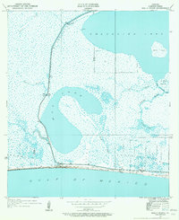
1934 Map of Holly Beach
USGS Topo · Published 1955About this map
Holly Beach sits at the edge of the Gulf of Mexico, serving as a focal point in a coastal landscape where the land and water are inextricably linked. The settlement is positioned along State Highway No 104, which runs parallel to the shore, providing a critical corridor through the low-lying terrain. The hydrography of the region is defined by large bodies of water like Calcasieu Lake and Mud Lake, connected by natural channels such as Mud Pass and Calcasieu Pass.
Find a feature on this map
19 named features on this map. Tap any name to fly to it.
Don’t see what you’re looking for? This feature index may not catch every label — zoom into the map to look around manually.
Map Details
Editions of this 1934 Holly Beach Map
2 editions found
Other maps of this area

1934 · Cameron
USGS Topo · 1:24,000

1934 · Holly Beach
USGS Topo · 1:24,000

1934 · Peveto Beach
USGS Topo · 1:24,000

1934 · Browns Lake
USGS Topo · 1:24,000

1934 · Five Lakes
USGS Topo · 1:24,000

1935 · Peveto Beach
USGS Topo · 1:31,680

1935 · Cameron
USGS Topo · 1:31,680

1935 · Five Lakes
USGS Topo · 1:31,680

1935 · Hackberry
USGS Topo · 1:31,680

1935 · Holly Beach
USGS Topo · 1:31,680