
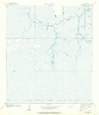
1934 Map of Greens Bayou
USGS Topo · Published 1960About this map
Black Bayou meanders across a landscape defined by intricate waterways and seasonal wetlands in this mid-1930s coastal Louisiana survey. The map details a transition from the elevated Pines Ridge down into the expansive marshlands of Cameron Parish. Human presence is marked by isolated outposts such as Lone Pine, Grays Camp, and Gate Camp, which likely served as seasonal bases for trapping, fishing, or canal maintenance.
Find a feature on this map
23 named features on this map. Tap any name to fly to it.
Don’t see what you’re looking for? This feature index may not catch every label — zoom into the map to look around manually.
Map Details
Editions of this 1934 Greens Bayou Map
2 editions found
Other maps of this area

1932 · Orange
USGS Topo · 1:62,500

1932 · Port Arthur NE
USGS Topo · 1:31,680

1934 · Johnsons Bayou
USGS Topo · 1:24,000

1934 · Peveto Beach
USGS Topo · 1:24,000

1934 · Five Lakes
USGS Topo · 1:24,000

1935 · Peveto Beach
USGS Topo · 1:31,680

1935 · Five Lakes
USGS Topo · 1:31,680

1935 · Greens Bayou
USGS Topo · 1:31,680

1935 · Johnsons Bayou
USGS Topo · 1:31,680

1943 · West of Johnson Bayou
USGS Topo · 1:24,000