
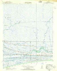
1943 Map of West of Johnson Bayou
USGS Topo · Published 1952About this map
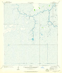
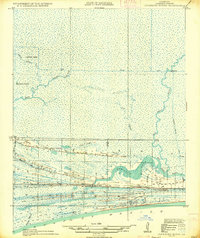
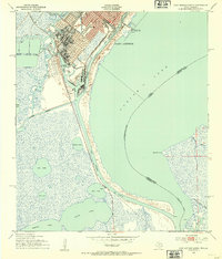
The coastal marshlands and cheniers of Cameron Parish are meticulously detailed in this mid-century survey, conducted during the Second World War. The landscape is defined by its complex hydrology, dominated by Sabine Lake and the Sabine National Wildlife Refuge. A series of distinctive ridges, likely ancient shorelines, rise above the wetlands, including Blue Buck Ridge, Back Ridge, and Garrison Ridge. These elevations provided the primary habitable land in this amphibious environment, as evidenced by the namesake Johnsons Bayou and the Johnsons Bayou Landing on the eastern edge. The map captures the intricate network of water bodies such as Madame Johnsons Bayou Lake and Willow Bayou, illustrating the era before extensive modern channelization modified the natural flow of these Gulf Coast bayous.
Find a feature on this map
25 named features on this map. Tap any name to fly to it.
Don’t see what you’re looking for? This feature index may not catch every label — zoom into the map to look around manually.
Map Details
Editions of this 1943 West of Johnson Bayou Map
This is the sole edition of this map. No revisions or reprints were ever made.
Other maps of this area

1932 · Sabine Pass NE
USGS Topo · 1:31,680

1932 · Port Arthur NE
USGS Topo · 1:31,680
1934 · Johnsons Bayou
USGS Topo · 1:24,000
1934 · Greens Bayou
USGS Topo · 1:24,000

1935 · Greens Bayou
USGS Topo · 1:31,680
1935 · Johnsons Bayou
USGS Topo · 1:31,680

1943 · West of Greens Bayou
USGS Topo · 1:24,000

1943 · Port Arthur North
USGS Topo · 1:24,000
1943 · Port Arthur South
USGS Topo · 1:24,000

1944 · Sabine Pass
USGS Topo · 1:31,680