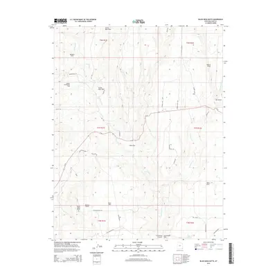
2014 Map of Black Mesa Butte
USGS Topo · Published 2014About this map
Black Mesa and its namesake Black Mesa Butte dominate this high-desert landscape south of Blanding. This 2014 survey captures a terrain defined by deep incisions such as Stevens Canyon and Big Canyon, where water has carved through the plateau to form a Natural Bridge. The map records a network of primitive access roads and trails that speak to the area's utility for livestock and resource extraction, including Shumway Mines Rd and the intriguing Black Mesa Missile site.
Find a feature on this map
42 named features on this map. Tap any name to fly to it.
Don’t see what you’re looking for? This feature index may not catch every label — zoom into the map to look around manually.
Map Details
Editions of this 2014 Black Mesa Butte Map
This is the sole edition of this map. No revisions or reprints were ever made.
Other maps of this area

1886 · Abajo
USGS Topo · 1:250,000

1892 · Abajo
USGS Topo · 1:250,000

1893 · Abajo
USGS Topo · 1:250,000

1935 · Elk Ridge
USGS Topo · 1:96,000

1940 · Elk Ridge
USGS Topo · 1:125,000

1954 · Elk Ridge 4 NW
USGS Topo · 1:24,000

1956 · Cortez
USGS Topo · 1:250,000
1957 · Elk Ridge 4 NE
USGS Topo · 1:24,000

1957 · Elk Ridge 4 SE
USGS Topo · 1:24,000

1957 · Brushy Basin Wash
USGS Topo · 1:62,500