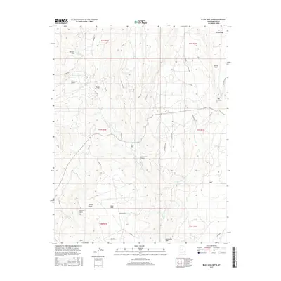
2017 Map of Black Mesa Butte
USGS Topo · Published 2017About this map
Blanding anchors the northern edge of this high-desert plateau, overlooking a landscape defined by deep drainages and isolated mesas. The terrain is marked by prominent geological features such as Black Mesa Butte and the curiously named Cheese and Raisins Hills, illustrating the distinct character of San Juan County's topography. Water is a critical element in this arid environment, represented by the winding courses of Cottonwood Creek and Westwater Creek, as well as localized points like Ruin Spring. Evidence of human activity and resource extraction is visible through the Shumway Mines and the Westwater Oil Well, while landmarks like the Natural Bridge and White Mesa suggest the area's geological diversity. An extensive network of backroads, including Army Road and Ruin Springs Road, provides access to these remote canyons and draws, tracing the routes used by local industry and residents through Cottonwood Canyon.
Find a feature on this map
44 named features on this map. Tap any name to fly to it.
Don’t see what you’re looking for? This feature index may not catch every label — zoom into the map to look around manually.
Map Details
Editions of this 2017 Black Mesa Butte Map
This is the sole edition of this map. No revisions or reprints were ever made.
Other maps of this area

1886 · Abajo
USGS Topo · 1:250,000

1892 · Abajo
USGS Topo · 1:250,000

1893 · Abajo
USGS Topo · 1:250,000

1935 · Elk Ridge
USGS Topo · 1:96,000

1940 · Elk Ridge
USGS Topo · 1:125,000

1954 · Elk Ridge 4 NW
USGS Topo · 1:24,000

1956 · Cortez
USGS Topo · 1:250,000
1957 · Elk Ridge 4 NE
USGS Topo · 1:24,000

1957 · Elk Ridge 4 SE
USGS Topo · 1:24,000

1957 · Brushy Basin Wash
USGS Topo · 1:62,500