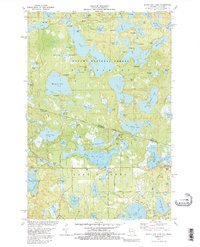
1981 Map of Black Oak Lake
USGS Topo · Published 1988About this map
Ottawa National Forest spans the border between Michigan and Wisconsin, blanketing a dense lake district defined by glacier-carved basins and winding forest roads. This 1981 edition captures the complex hydrography of the region, where countless named water bodies like Whitefish Lake, Katherine Lake, and Loon Lake are separated by narrow ridges and marshy lowlands. Human development is concentrated around the southern edge near Land O' Lakes, where the Oak Hill Cem and local infrastructure like the Fish Hatchery and Gravel Pit appear alongside recreational camps. The map documents a landscape balanced between heavy conservation and seasonal tourism, evidenced by the numerous campgrounds and boat ramps tucked away in areas like Sylvania. Interesting hydrological features like Johnston Springs and a series of sewage disposal ponds reflect the intersection of the natural water table with the needs of the local settlements and the forest service.
Find a feature on this map
91 named features on this map. Tap any name to fly to it.
Don’t see what you’re looking for? This feature index may not catch every label — zoom into the map to look around manually.
Map Details
Editions of this 1981 Black Oak Lake Map
2 editions found
Other maps of this area

1938 · Phelps
USGS Topo · 1:48,000

1946 · Star Lake
USGS Topo · 1:48,000

1950 · Phelps
USGS Topo · 1:48,000

1950 · Star Lake
USGS Topo · 1:48,000

1952 · Watersmeet
USGS Topo · 1:62,500

1952 · Thayer
USGS Topo · 1:62,500

1955 · Starlake
USGS Topo · 1:62,500

1956 · Phelps
USGS Topo · 1:62,500

1958 · Iron River
USGS Topo · 1:250,000

1960 · Iron River
USGS Topo · 1:250,000