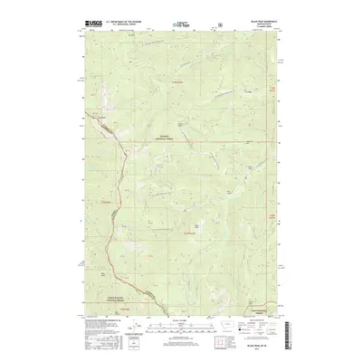
2017 Map of Black Peak
USGS Topo · Published 2017About this map
Kaniksu National Forest, Coeur D'Alene National Forest, and Lolo National Forest converge along the high ridges of the Bitterroot Range, where the State Line separates Shoshone County, Idaho, from Sanders County, Montana. This high-elevation terrain is defined by prominent summits including Black Peak, Sex Peak, and Haystack Mtn. The drainage system is heavily influenced by these peaks, with headwaters such as White Pine Cr and Big Beaver Cr carving deep gulches through the protected timberlands. Access to these remote reaches is limited to rugged corridors like Whitepine Creek Rd and various Forest Development roads. The survey captures the intricate boundary system where federal forest lands and state borders intersect at significant landmarks like Jew Peak and Emma Peak, providing an essential view of the geographic divide between the Idaho Panhandle and Western Montana.
Find a feature on this map
44 named features on this map. Tap any name to fly to it.
Don’t see what you’re looking for? This feature index may not catch every label — zoom into the map to look around manually.
Map Details
Editions of this 2017 Black Peak Map
This is the sole edition of this map. No revisions or reprints were ever made.
Other maps of this area

1901 · Coeur D'Alene District
USGS Topo · 1:62,500

1903 · Coeur D'Alene District
USGS Topo · 1:62,500

1906 · Coeur D'Alene District
USGS Topo · 1:62,500

1932 · Trout Creek
USGS Topo · 1:125,000

1935 · Trout Creek
USGS Topo · 1:125,000

1936 · Trout Creek
USGS Topo · 1:125,000

1956 · Cooper Gulch
USGS Topo · 1:62,500

1956 · Wallace
USGS Topo · 1:250,000

1957 · Burke
USGS Topo · 1:62,500

1960 · Wallace
USGS Topo · 1:250,000