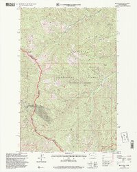
1997 Map of Black Peak
USGS Topo · Published 2000About this map
Idaho and Montana borderlines converge at the Cabinet Mountains Wilderness on this late 1990s survey, illustrating a landscape defined by industrial extraction and forest management. The presence of a Mine Shaft and multiple prospects near the Duthie site indicates the history of mineral exploration in these mountains, while a prominent Gravel Pit along Beaver Creek suggests ongoing resource use. High-altitude landmarks like the Sex Peak Lookout and Black Peak overlook a complex network of drainage basins, including White Pine Creek and Cole Creek. The map documents the administrative boundaries of several protected lands, showing how the Kaniksu National Forest is managed by the Kootenai National Forest, intersecting with the Coeur d'Alene National Forest and Lolo National Forest.
Find a feature on this map
44 named features on this map. Tap any name to fly to it.
Don’t see what you’re looking for? This feature index may not catch every label — zoom into the map to look around manually.
Map Details
Editions of this 1997 Black Peak Map
This is the sole edition of this map. No revisions or reprints were ever made.
Other maps of this area

1901 · Coeur D'Alene District
USGS Topo · 1:62,500

1903 · Coeur D'Alene District
USGS Topo · 1:62,500

1906 · Coeur D'Alene District
USGS Topo · 1:62,500

1932 · Trout Creek
USGS Topo · 1:125,000

1935 · Trout Creek
USGS Topo · 1:125,000

1936 · Trout Creek
USGS Topo · 1:125,000

1956 · Cooper Gulch
USGS Topo · 1:62,500

1956 · Wallace
USGS Topo · 1:250,000

1957 · Burke
USGS Topo · 1:62,500

1960 · Wallace
USGS Topo · 1:250,000