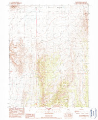
1990 Map of Black Point
USGS Topo · Published 1990About this map
Eighteenmile House (Site) stands as a lonely historical marker in this 1990 provisional study, situated where the Newark Valley meets the high ground. The terrain is defined by the stark intersection of the Black Point Range and the Pancake Range, showing a landscape heavily shaped by both natural drainage and human resource extraction. Resource exploration is evident through scattered Prospect labels and a Mine Shaft, alongside industrial features like a Quarry and Gravel Pit. The map captures the vital role of water management in this arid White Pine County environment, noting numerous Wells, including the named Black Shade Well, and several Stock Ponds and Springs. These features, along with a marked Corral, suggest a ranching economy that persisted long after the primary activity at the Eighteenmile House site had ceased.
Find a feature on this map
17 named features on this map. Tap any name to fly to it.
Don’t see what you’re looking for? This feature index may not catch every label — zoom into the map to look around manually.
Map Details
Editions of this 1990 Black Point Map
This is the sole edition of this map. No revisions or reprints were ever made.
Other maps of this area

1951 · Green Springs
USGS Topo · 1:62,500

1951 · Pancake Summit
USGS Topo · 1:62,500

1953 · Pinto Summit
USGS Topo · 1:62,500

1956 · Ely
USGS Topo · 1:250,000

1959 · Ely
USGS Topo · 1:250,000

1963 · Ely
USGS Topo · 1:250,000

1964 · Moody Peak
USGS Topo · 1:62,500

1979 · Mt. Hamilton
USGS Topo · 1:100,000

1990 · Pancake Summit SW
USGS Topo · 1:24,000
1990 · Green Springs NW
USGS Topo · 1:24,000