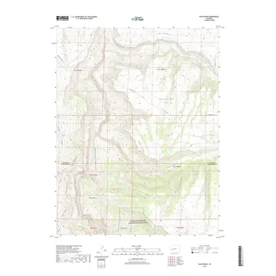
2019 Map of Black Ridge
USGS Topo · Published 2019About this map
Fruitland Mesa and Scenic Mesa dominate this portion of the Western Slope, where the high desert landscape is deeply carved by the Gunnison River. This survey illustrates the intricate water management system essential for high-altitude agriculture, featuring the Grand View Ditch and the Fruitland Mesa Ditch. To the south, the map details the dramatic northern boundary of the Black Canyon of the Gunnison National Park, where the terrain drops sharply toward the river floor. Traditional land use and transit are evident in the presence of Pitts Meadow and the winding Red Rocks-Nighthorse Trail. The map also traces the convergence of significant natural drainages such as Smith Fork and the arid depths of Lime Kiln Gulch, providing a detailed view of the rugged boundary between Delta and Montrose counties.
Find a feature on this map
31 named features on this map. Tap any name to fly to it.
Don’t see what you’re looking for? This feature index may not catch every label — zoom into the map to look around manually.
Map Details
Editions of this 2019 Black Ridge Map
This is the sole edition of this map. No revisions or reprints were ever made.
Other maps of this area

1955 · Olathe NW
USGS Topo · 1:24,000

1955 · Black Ridge
USGS Topo · 1:24,000

1955 · Olathe
USGS Topo · 1:24,000

1955 · Red Rock Canyon
USGS Topo · 1:24,000

1955 · Lazear
USGS Topo · 1:24,000

1956 · Montrose
USGS Topo · 1:250,000

1957 · Grizzly Ridge
USGS Topo · 1:24,000

1959 · Montrose
USGS Topo · 1:250,000

1960 · Montrose
USGS Topo · 1:250,000
1962 · Orchard City
USGS Topo · 1:24,000