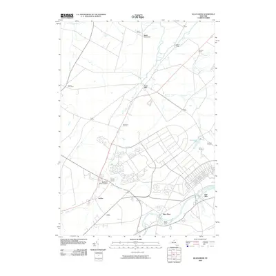
2010 Map of Black River
USGS Topo · Published 2010About this map
Evans Mills and the namesake Black River anchor this Jefferson County landscape, where the hydrography of the Indian River and Pleasant Creek once drove local industry. The map documents a dense network of hamlets and crossroads, including Dutch Settlement, Pamelia Four Corners, and Felts Mills. For researchers of local history, the inclusion of the Leray Mansion and several well-defined burial grounds, such as Hoover Cemetery and Sheepfold Cemetery, provides a clear view of the area's social and geographic lineage. The terrain is marked by significant river features like Poors Island and the Anstead Bridge crossing. The settlement pattern reveals how rail and road corridors influenced the growth of communities like Calcium and Sanfords Four Corners, mapping the evolving suburban and agricultural character of the region as it stood in 2010.
Find a feature on this map
31 named features on this map. Tap any name to fly to it.
Don’t see what you’re looking for? This feature index may not catch every label — zoom into the map to look around manually.
Map Details
Editions of this 2010 Black River Map
This is the sole edition of this map. No revisions or reprints were ever made.
Other maps of this area

1895 · Watertown
USGS Topo · 1:62,500

1898 · Watertown
USGS Topo · 1:62,500

1902 · Carthage
USGS Topo · 1:62,500

1903 · Theresa
USGS Topo · 1:62,500

1904 · Carthage
USGS Topo · 1:62,500

1908 · Watertown
USGS Topo · 1:62,500

1909 · Watertown
USGS Topo · 1:62,500

1911 · Antwerp
USGS Topo · 1:62,500

1942 · Copenhagen
USGS Topo · 1:24,000
1943 · Watertown
USGS Topo · 1:31,680