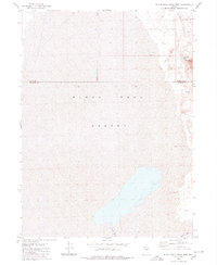
1980 Map of Black Rock Point West
USGS Topo · Published 1980About this map
Black Rock Desert dominates this 1980 survey, revealing a landscape defined by its vast alkali flats and hydrothermal activity. The area sits at the intersection of the Humboldt and Pershing County line, where the terminal Quinn River spreads across the desert floor. This map captures the natural geography of the Great Basin, focusing on the prominent Black Rock Point and the geothermal features that dot the eastern margin of the playa. Geothermal activity is central to the area's identity, with both Black Rock Springs and additional Hot Springs noted along the desert edge. Infrastructure is nearly nonexistent, limited to a single Jeep Trail and a lone Well, illustrating the isolation of this corner of Nevada before it became a globally recognized event site.
Find a feature on this map
8 named features on this map. Tap any name to fly to it.
Don’t see what you’re looking for? This feature index may not catch every label — zoom into the map to look around manually.
Map Details
Editions of this 1980 Black Rock Point West Map
2 editions found
Other maps of this area

1886 · Disaster
USGS Topo · 1:250,000

1886 · Granite Range
USGS Topo · 1:250,000

1889 · Long Valley
USGS Topo · 1:250,000

1893 · Disaster
USGS Topo · 1:250,000

1894 · Granite Range
USGS Topo · 1:250,000

1931 · Lovelock
USGS Topo · 1:250,000

1935 · Lovelock
USGS Topo · 1:250,000

1954 · Vya
USGS Topo · 1:250,000

1955 · Lovelock
USGS Topo · 1:250,000

1958 · Vya
USGS Topo · 1:250,000