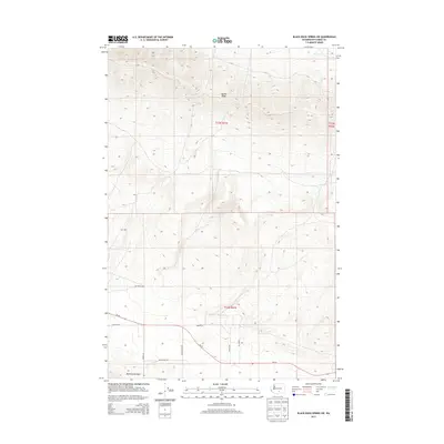
2013 Map of Black Rock Spring SW
USGS Topo · Published 2013About this map
Yakima Ridge and the Rattlesnake Hills dominate this section of the high desert, where the elevation drops into the drainage of Selah Cr at the northern edge. The landscape is characterized by a high-elevation plateau marked by steep ridges and sparse water sources, indicative of the arid interior of Yakima County. Transportation is concentrated in the southern half of the quadrangle, primarily along the corridor of Wa-24. Here, a network of local roads including Desmarais Rd and Den Beste Rd serves the rural properties and access points between the ridges. The survey captures the transition from the rugged upland terrain to the more accessible valley areas, showing a layout of section lines and isolated tracks like Suntargets Rd and Prairie Dog Rd that trace the local land use patterns of the early 21st century.
Find a feature on this map
15 named features on this map. Tap any name to fly to it.
Don’t see what you’re looking for? This feature index may not catch every label — zoom into the map to look around manually.
Map Details
Editions of this 2013 Black Rock Spring SW Map
This is the sole edition of this map. No revisions or reprints were ever made.
Other maps of this area

1910 · Zillah
USGS Topo · 1:125,000

1936 · Yakima East
USGS Topo · 1:48,000

1936 · Hog Ranch Buttes
USGS Topo · 1:48,000

1941 · Black Rock Spring
USGS Topo · 1:62,500

1941 · Yakima East
USGS Topo · 1:62,500

1950 · Yakima
USGS Topo · 1:250,000
1953 · Black Rock Spring NW
USGS Topo · 1:24,000
1953 · Black Rock Spring SW
USGS Topo · 1:24,000

1953 · Elephant Mountain
USGS Topo · 1:24,000
1953 · Black Rock Spring
USGS Topo · 1:24,000